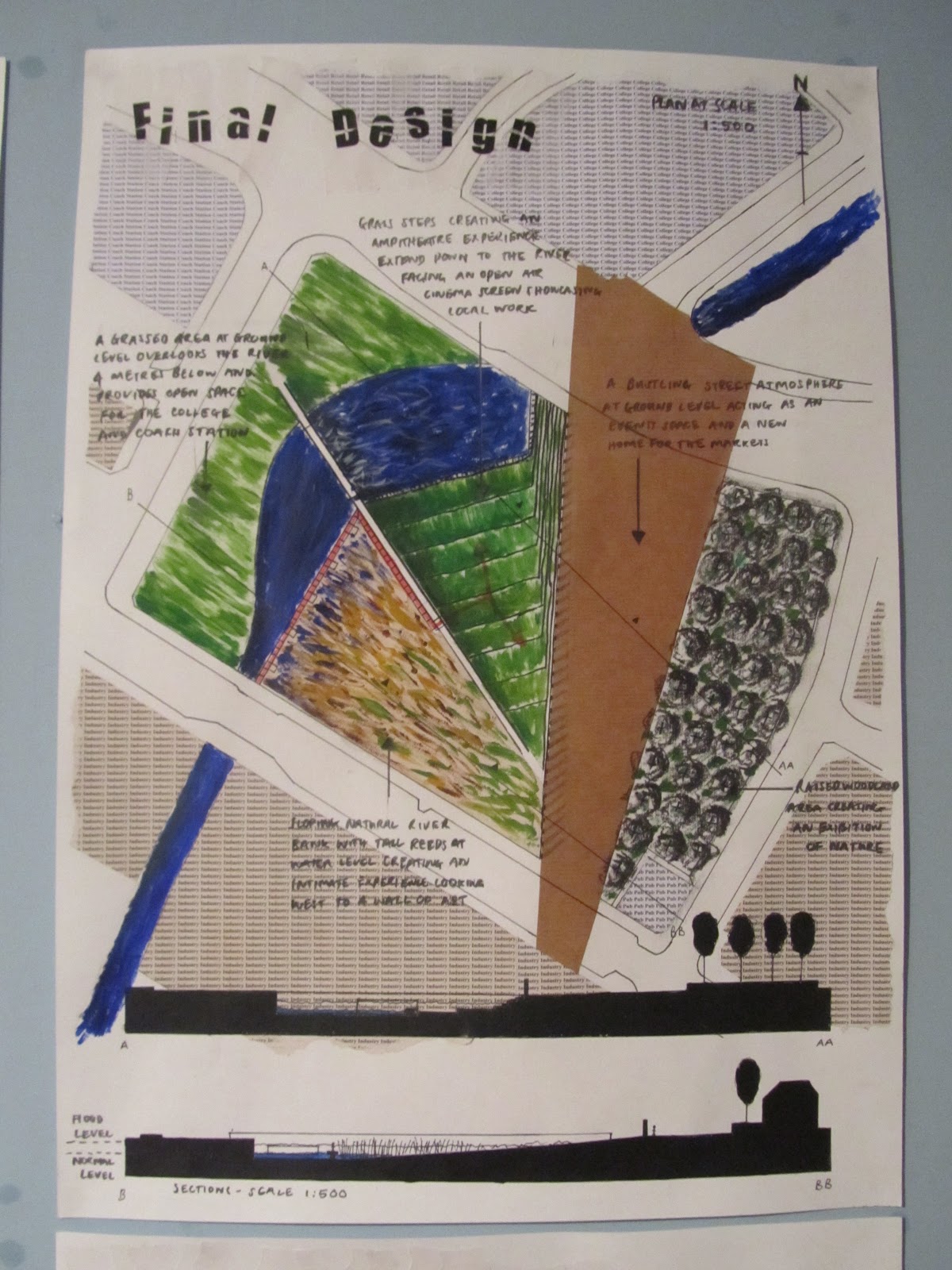
Final Design
The photo gives an idea of the different areas in the park and how the levels, pace, planting constantly change forming these contrasting experiences.
Final Design: A constantly changing experience
The photo shows my final plan, a park where the experience changes as you move through it, where the experience changes throughout the day in terms of shadows, where the experience changes though out the year with reed dying back creating an open space and water levels changing and where the experience changes as artwork exhibited changes.
Design Development
Forming a masterplan
Photo shows how I am beginning to develop a master plan with the 'changing landscape' concept in mind. Each park would provide a different experience responding specifically to its surrounding area and there would also be the element of change within each park.
Cheonggyecheon Stream: Design within a culvert
Photo shows a bit more investigation into the Cheonggyecheon Stream and how it passes through different zones. The design of the channel from zone to zone dramatically changes and I am beginning to explore how that might apply in the River Rea channel from a concrete base to a small cantilevered walkway.
Cheonggyecheon Stream Seoul
Really interesting in terms of manipulating water to create various sounds and experiences to the area and also the interaction of humans and water through stepping stones brings out a playful side within all of us and a sense of danger contributes to the experience.
The High Line New York
A great precedent and again I was really interested in the creation of the different experiences with a very linear flat area that shares similarities with the River Rea culvert. From low lying meadows combined with straight paths and long views to forested areas with zig zagging paths and small views.
Moses Bridge: A completely different experience
http://www.landezine.com/index.php/2011/11/moses-bridge-by-road-architects/
Another interesting precedent and one that is quite appropriate to my concept. I am really interested in the changing experience when you stand on a platform hovering above the water compared with a intervention such as Moses Bridge where you stand below the water line. Must feel much more enclosed and vulnerable to nature, also it gives you the chance to see things on a micro scale creating a greater intimacy.
Sanlihe Ecology Corridor
http://www.landezine.com/index.php/2012/01/ecological-coridor-landscape-architecture/
Great project in China, transforming a highly polluted industrial river into an ecology park. In terms of my design and the River Rea the segmented planting patterns in the Sanlihe corridor are a really interesting aspect and the idea of this very obvious change applies to my concept 'changing landscape'.
Further Site Analysis
After identifying four specific sites for possible development the photos show greater detailed analysis into these sites looking into the surrounding land use, pedestrian movement, and sections that will be extremely useful later when designing especially as the river is prone to flooding.
Already I am beginning to develop a concept from the site analysis around the idea of 'a changing landscape' with the areas around the river changing throughout from residential to industrial. And also the constantly changing water levels.
The High Line: Changing Pace
Ideas such as not letting bikes on the High Line contributes to this experience where pedestrians relax and amble along the route rather than race around. However it is also the the changing experiences as you walk the route with low growing wild flowers to taller dense vegetation and canopy walks could all help to inform the River Rea design.
Visual Connections
Initial Site Analysis
After investigating the local area, it is clear there are four key sites along the river that are existing open space. The central site will be crucial as it cross's Deritend High Street which is a important entrance into the city centre. This is an area surely where the river should be visible and the site makes people notice whats around them with it enticing people into the space.
The brown paper represents the strong industrial presence still in this area with some interesting architecture including the typical triangular roofing and the railway viaduct. There is also a strong grid like street pattern in the south which looking forward may inform the design.
Other key elements is the rivers constantly fluctuating water level, with much of the surrounding area being impermeable leading to storm water run off. This provides an exciting chance to use these fluctuating levels within the design.
A Hidden Treasure
The River Rea is a culverted river slicing straight through the heart of Birmingham's industrial area's: Digbeth and Deritend east of the city centre.
The site area stretches approximately 2.2km from south to north and offers the unique opportunity to investigate into the ecopsychology, and the role of landscape architecture in health and well being. But most importantly it offers a great opportunity to reconnect this forgotten river with the population.
Subscribe to:
Posts (Atom)